AI-Based High-Resolution Forest Monitoring ongoing
Preserving global vegetation is crucial for addressing and mitigating climate change. Accurate, up-to-date forest health data is essential. AI4Forest aims to develop advanced AI methods to monitor forests using satellite imagery, including radar and optical data. The project will create scalable techniques for detailed, high-resolution maps of the globe, e.g., to monitor canopy height, biomass, and to track forest disturbances. Please also visit the project website at ai4forest.eu.
🧑🎓 Project Members (excluding external)
🪙 Funding
This project is being funded by the Federal Ministry of Research, Technology and Space and the VDI/VDE Innovation + Technik GmbH (project ID 16IS23025B) from June 2023 to May 2027.

🔬 Project Description
Accurate and up-to-date information on global forest health, disturbances, evolution of above ground biomass and carbon storage is essential for policy-makers to design effective strategies for climate adaptation and mitigation. Advances in Earth observation and AI have paved the way for automated forest monitoring using satellite data, along with radar and LiDAR data. However, existing forest maps often have low resolution, cover limited areas or fail to track temporal dynamics.
The AI4Forest project brings together experts in AI, Applied Mathematics, Computer Science, Remote Sensing, and Climate Science, being a collaboration between ZIB, LSCE, CNRS, WWU and TUM. The project aims to develop scalable AI methods for forest monitoring and to efficiently and cost-effectively process large datasets. These advancements will enable the creation of detailed forest maps with high spatial and temporal resolution, down to individual trees and species, and allow for regular updates across Europe and globally.
Estimating Canopy Height at Scale
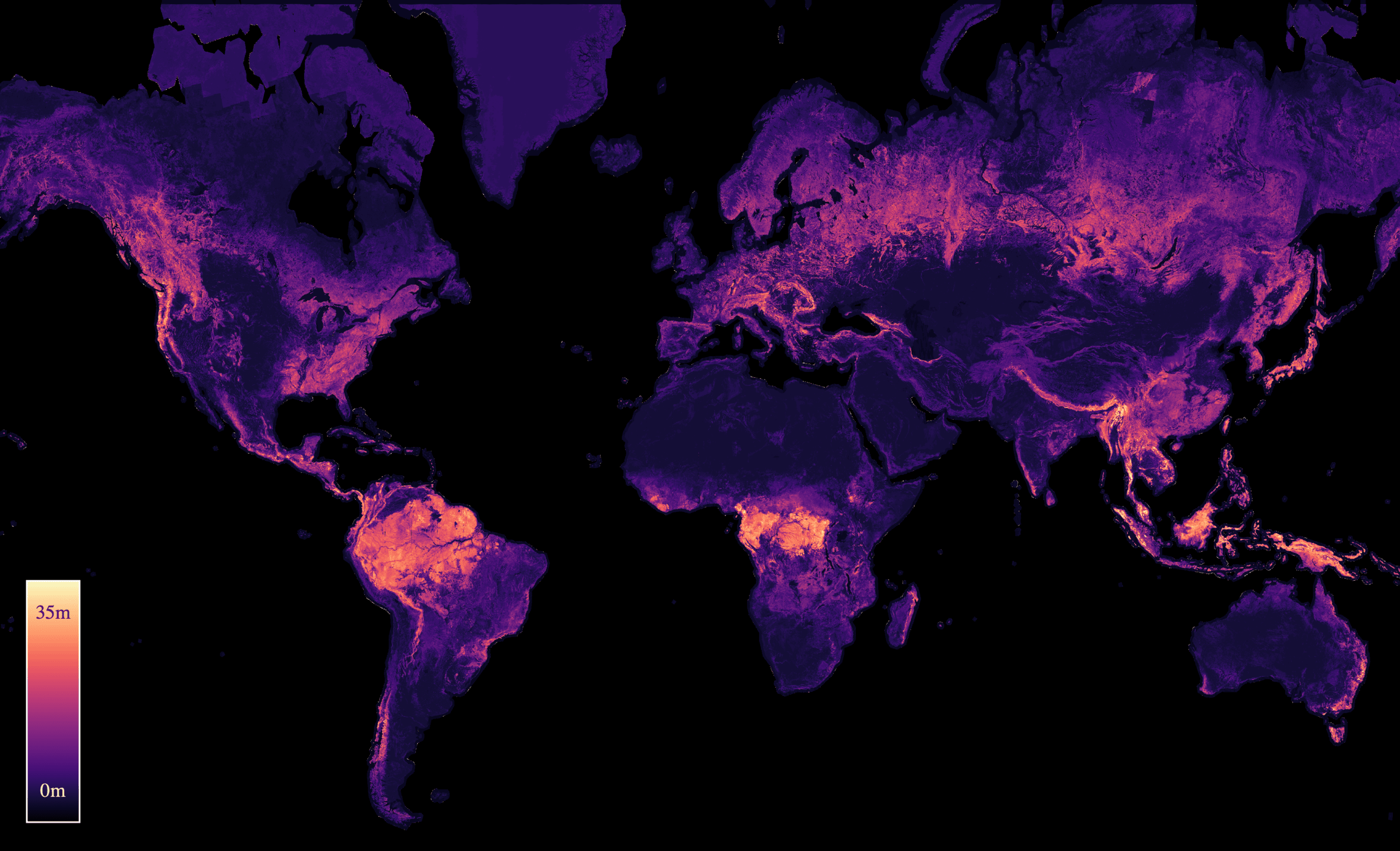
Recently, we released a global canopy height map with a 10m resolution, based on satellite data from 2020. You can find the paper on arXiv. Below is an image of the height map, you can explore the interactive global map on the Google Earth Engine.
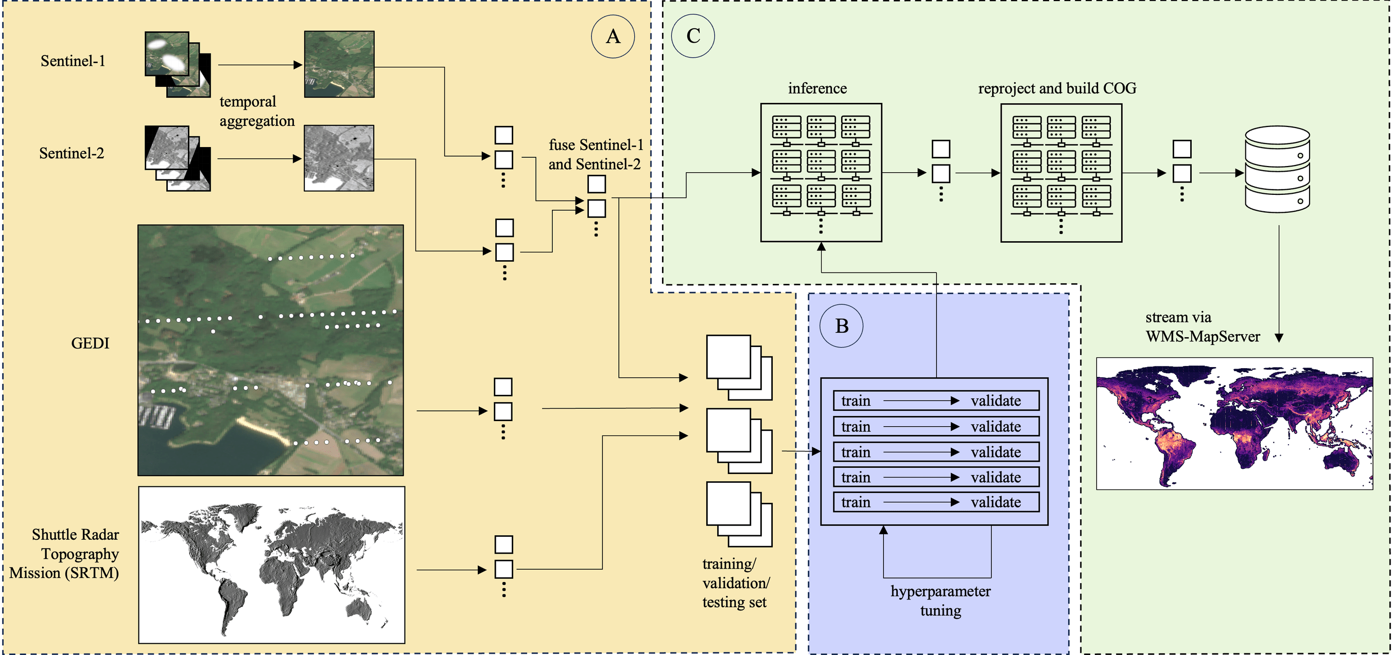
The computational pipeline to produce the height map can be visualized as follows:
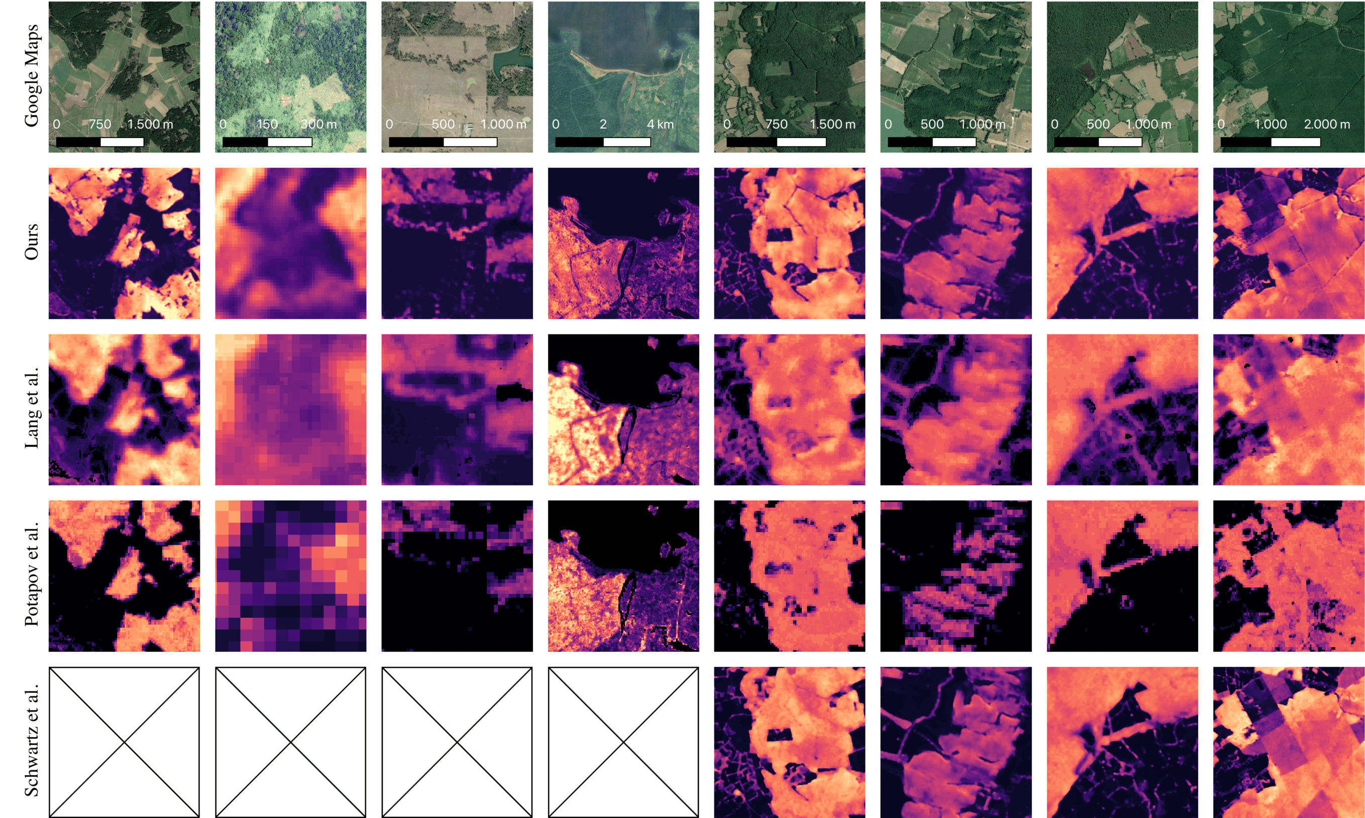
Comparing our map with two other existing global height maps (Lang et al., Potapov et al.), as well as a regional map for France, shows a significant improvement in visual quality.
Capturing Temporal Dynamics in Large-Scale Canopy Tree Height Estimation
Going a step further, we also built a model that takes the temporal evolution of canopy height over multiple years into account. A crucial step in this process, which we describe in our paper, is to use 12 images per year (i.e., one image per month) as input, as opposed to a median-composite. While this is computationally more expensive and could include more clouds, the model is able to capture seasonal variations as well as geolocation shifts. While we provide the first map at 10m resolution for the entire european continent and for years 2019-2022, our model is able to estimate canopy height much better, as the following comparison to the ALS ground truth shows.
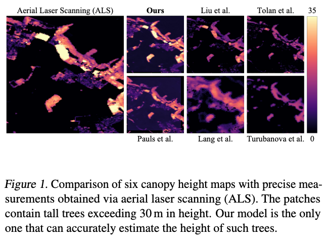
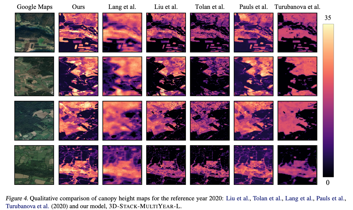
Restricting our model to predicting only the height map for the year 2020, we can compare the results to other maps for the same year, including our previous map. We are able to significantly improve both the visual quality as well as the accuracy of the map.
💬 Talks and posters
Poster presentations
- Jul 2025
- Capturing Temporal Dynamics in Large-Scale Canopy Tree Height Estimation by Berkant Turan and Max Zimmer
42nd International Conference on Machine Learning (ICML), Vancouver - Jul 2025
- DUNIA: Pixel-Sized Embeddings Via Cross-Modal Alignment for Earth Observation Applications by Max Zimmer
42nd International Conference on Machine Learning (ICML), Vancouver - Jul 2024
- Estimating Canopy Height at Scale by Max Zimmer
41st International Conference on Machine Learning (ICML), Vienna - May 2024
- Sparse Model Soups a Recipe for Improved Pruning Via Model Averaging by Max Zimmer
12th International Conference on Learning Representations (ICLR), Vienna - May 2023
- How I Learned to Stop Worrying and Love Retraining by Max Zimmer
11th International Conference on Learning Representations (ICLR), Kigali - Mar 2023
- How I Learned to Stop Worrying and Love Retraining by Max Zimmer
Workshop on Optimization and Machine Learning, Waischenfeld
📝 Publications and preprints
Preprints
- Pelleriti, N., Spiegel, C., Liu, S., Martínez-Rubio, D., Zimmer, M., and Pokutta, S. (2025). Neural Sum-of-Squares: Certifying the Nonnegativity of Polynomials with Transformers.
DOI: 10.48550/arXiv.2510.13444
[arXiv]
[BibTeX]
@misc{2025_PelleritiEtAl_Neuralsos_2510-13444, month = oct, doi = {10.48550/arXiv.2510.13444}, archiveprefix = {arXiv}, eprint = {2510.13444}, arxiv = {arXiv:2510.13444}, primaryclass = {cs.LG}, year = {2025}, author = {Pelleriti, Nico and Spiegel, Christoph and Liu, Shiwei and Martínez-Rubio, David and Zimmer, Max and Pokutta, Sebastian}, title = {Neural Sum-of-Squares: Certifying the Nonnegativity of Polynomials with Transformers}, date = {2025-10-16} } - Roux, C., Zimmer, M., d’Aspremont, A., and Pokutta, S. (2025). Don’t Be Greedy, Just Relax! Pruning LLMs Via Frank-Wolfe.
DOI: 10.48550/arXiv.2510.13713
[arXiv]
[BibTeX]
@misc{2025_RouxZimmerDaspremontPokutta_Pruningfrankwolfe_2510-13713, month = oct, doi = {10.48550/arXiv.2510.13713}, archiveprefix = {arXiv}, eprint = {2510.13713}, arxiv = {arXiv:2510.13713}, primaryclass = {cs.LG}, year = {2025}, author = {Roux, Christophe and Zimmer, Max and d'Aspremont, Alexandre and Pokutta, Sebastian}, title = {Don't Be Greedy, Just Relax! Pruning LLMs Via Frank-Wolfe}, date = {2025-10-16} } - Wagner, M., Roux, C., Zimmer, M., and Pokutta, S. (2025). A Free Lunch in LLM Compression: Revisiting Retraining After Pruning.
DOI: 10.48550/arXiv.2510.14444
[arXiv]
[BibTeX]
@misc{2025_WagnerRouxZimmerPokutta_Llmpruningretraining_2510-14444, month = oct, doi = {10.48550/arXiv.2510.14444}, archiveprefix = {arXiv}, eprint = {2510.14444}, arxiv = {arXiv:2510.14444}, primaryclass = {cs.LG}, year = {2025}, author = {Wagner, Moritz and Roux, Christophe and Zimmer, Max and Pokutta, Sebastian}, title = {A Free Lunch in LLM Compression: Revisiting Retraining After Pruning}, date = {2025-10-17} } - Urbano, A., Romero, D. W., Zimmer, M., and Pokutta, S. (2025). RECON: Robust Symmetry Discovery Via Explicit Canonical Orientation Normalization.
DOI: 10.48550/arXiv.2505.13289
[arXiv]
[BibTeX]
@misc{2025_UrbanoWZimmerPokutta_Reconsymmetrydiscovery, month = may, doi = {10.48550/arXiv.2505.13289}, archiveprefix = {arXiv}, eprint = {2505.13289}, arxiv = {arXiv:2505.13289}, primaryclass = {cs.LG}, year = {2025}, author = {Urbano, Alonso and Romero, David W. and Zimmer, Max and Pokutta, Sebastian}, title = {RECON: Robust Symmetry Discovery Via Explicit Canonical Orientation Normalization}, date = {2025-05-19} } - Zimmer, M., Roux, C., Wagner, M., Hendrych, D., and Pokutta, S. (2025). SparseSwaps: Tractable LLM Pruning Mask Refinement at Scale.
[arXiv]
[BibTeX]
@misc{2025_ZimmerEtAl_Sparseswapspruning_2512-10922,
  archiveprefix = {arXiv},
  eprint = {2512.10922},
  arxiv = {arXiv:2512.10922},
  primaryclass = {cs.LG},
  year = {2025},
  author = {Zimmer, Max and Roux, Christophe and Wagner, Moritz and Hendrych, Deborah and Pokutta, Sebastian},
  title = {SparseSwaps: Tractable LLM Pruning Mask Refinement at Scale},
  date = {2025-12-11}
}
Conference proceedings
- Kera, H., Pelleriti, N., Ishihara, Y., Zimmer, M., and Pokutta, S. (2025, May 30). Computational Algebra with Attention: Transformer Oracles for Border Basis Algorithms. Proceedings of the Conference on Neural Information Processing Systems.
DOI: 10.48550/arXiv.2505.23696
[arXiv]
[BibTeX]
@inproceedings{2025_KeraEtAl_Transformeroracles_2505-23696, year = {2025}, booktitle = {Proceedings of the Conference on Neural Information Processing Systems}, month = sep, doi = {10.48550/arXiv.2505.23696}, archiveprefix = {arXiv}, eprint = {2505.23696}, arxiv = {arXiv:2505.23696}, primaryclass = {cs.LG}, author = {Kera, Hiroshi and Pelleriti, Nico and Ishihara, Yuki and Zimmer, Max and Pokutta, Sebastian}, title = {Computational Algebra with Attention: Transformer Oracles for Border Basis Algorithms}, date = {2025-05-30} } - Pauls, J., Zimmer, M., Turan, B., Saatchi, S., Ciais, P., Pokutta, S., and Gieseke, F. (2025, January 31). Capturing Temporal Dynamics in Large-Scale Canopy Tree Height Estimation. Proceedings of the International Conference on Machine Learning.
DOI: 10.48550/arXiv.2501.19328
[arXiv]
[BibTeX]
@inproceedings{2025_JanEtAl_Temporalcanopyheight, year = {2025}, booktitle = {Proceedings of the International Conference on Machine Learning}, month = may, doi = {10.48550/arXiv.2501.19328}, archiveprefix = {arXiv}, eprint = {2501.19328}, arxiv = {arXiv:2501.19328}, primaryclass = {cs.LG}, author = {Pauls, Jan and Zimmer, Max and Turan, Berkant and Saatchi, Sassan and Ciais, Philippe and Pokutta, Sebastian and Gieseke, Fabian}, title = {Capturing Temporal Dynamics in Large-Scale Canopy Tree Height Estimation}, date = {2025-01-31} } - Fayad, I., Zimmer, M., Schwartz, M., Ciais, P., Gieseke, F., Belouze, G., Brood, S., De Truchis, A., and d’Aspremont, A. (2025, February 24). DUNIA: Pixel-Sized Embeddings Via Cross-Modal Alignment for Earth Observation Applications. Proceedings of the International Conference on Machine Learning.
[arXiv]
[BibTeX]
@inproceedings{2025_IbrahimEtAl_DuniaCrossmodalalignment, year = {2025}, booktitle = {Proceedings of the International Conference on Machine Learning}, archiveprefix = {arXiv}, eprint = {2502.17066}, arxiv = {arXiv:2502.17066}, primaryclass = {cs.CV}, author = {Fayad, Ibrahim and Zimmer, Max and Schwartz, Martin and Ciais, Philippe and Gieseke, Fabian and Belouze, Gabriel and Brood, Sarah and De Truchis, Aurelien and d'Aspremont, Alexandre}, title = {DUNIA: Pixel-Sized Embeddings Via Cross-Modal Alignment for Earth Observation Applications}, date = {2025-02-24} } - Pauls, J., Zimmer, M., Kelly, U. M., Schwartz, M., Saatchi, S., Ciais, P., Pokutta, S., Brandt, M., and Gieseke, F. (2024, June 4). Estimating Canopy Height at Scale. Proceedings of the International Conference on Machine Learning.
[arXiv]
[code]
[BibTeX]
@inproceedings{2024_PaulsEtAl_Canopyheightestimation, year = {2024}, booktitle = {Proceedings of the International Conference on Machine Learning}, month = may, archiveprefix = {arXiv}, eprint = {2406.01076}, arxiv = {arXiv:2406.01076}, primaryclass = {cs.CV}, author = {Pauls, Jan and Zimmer, Max and Kelly, Una M and Schwartz, Martin and Saatchi, Sassan and Ciais, Philippe and Pokutta, Sebastian and Brandt, Martin and Gieseke, Fabian}, title = {Estimating Canopy Height at Scale}, code = {https://github.com/AI4Forest/Global-Canopy-Height-Map}, date = {2024-06-04} } - Zimmer, M., Spiegel, C., and Pokutta, S. (2024). Sparse Model Soups: A Recipe for Improved Pruning Via Model Averaging. Proceedings of the International Conference on Learning Representations.
[URL]
[arXiv]
[BibTeX]
@inproceedings{2023_ZimmerSpiegelPokutta_Sparsemodelsoups, year = {2024}, booktitle = {Proceedings of the International Conference on Learning Representations}, url = {https://iclr.cc/virtual/2024/poster/17433}, archiveprefix = {arXiv}, eprint = {2306.16788}, arxiv = {arXiv:2306.16788}, primaryclass = {cs.LG}, author = {Zimmer, Max and Spiegel, Christoph and Pokutta, Sebastian}, title = {Sparse Model Soups: A Recipe for Improved Pruning Via Model Averaging} } - Zimmer, M., Spiegel, C., and Pokutta, S. (2023). How I Learned to Stop Worrying and Love Retraining. Proceedings of the International Conference on Learning Representations.
[URL]
[arXiv]
[code]
[BibTeX]
@inproceedings{2021_ZimmerSpiegelPokutta_Retrainingpruning,
  year = {2023},
  booktitle = {Proceedings of the International Conference on Learning Representations},
  url = {https://iclr.cc/virtual/2023/poster/10914},
  archiveprefix = {arXiv},
  eprint = {2111.00843},
  arxiv = {arXiv:2111.00843},
  primaryclass = {cs.LG},
  author = {Zimmer, Max and Spiegel, Christoph and Pokutta, Sebastian},
  title = {How I Learned to Stop Worrying and Love Retraining},
  code = {https://github.com/ZIB-IOL/BIMP}
}


